


The Day the Mountain Broke: What the Nepal–Tibet Catastrophe Is Warning the World About
FEATURE
In the high Himalayas, danger does not always arrive with a long warning. Sometimes it begins far above the settlements, beyond ordinary sight, where ice, rock, snow and water have been held together for centuries by a delicate balance of temperature and terrain.
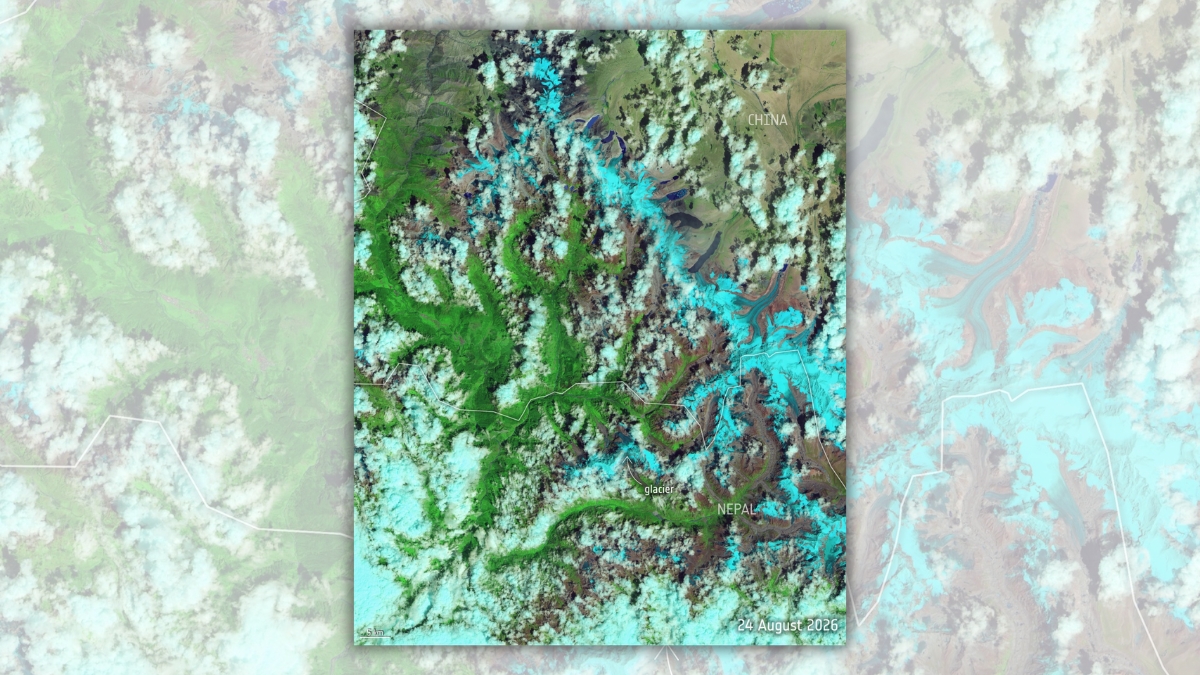
On 26 August 2026, that balance failed near the border between Nepal and Tibet.
A vast mass of glacier ice and rock broke away in the mountains. It descended with such force that seismic instruments initially registered a disturbance resembling an earthquake. As it gathered water, mud, boulders and debris, the collapse became a destructive surge that travelled through steep river valleys, striking settlements, roads, bridges, border facilities and hydropower projects.
People downstream had little time to understand what was coming.
Within days, the disaster had become one of the deadliest Himalayan catastrophes in recent memory. As this article was prepared on 2 September, Nepalese authorities had reported more than 1,100 deaths and over 3,900 people missing. China had confirmed deaths and hundreds missing on the Tibetan side. The figures continued to change as communication was restored and previously isolated areas were reached.
The missing included local residents, migrant workers, hydropower employees, pilgrims and tourists from dozens of countries. Hundreds of foreign nationals were unaccounted for. Indian citizens were among those caught in the disaster, adding a deeply personal dimension for families waiting anxiously for information across the border.
But the scale of human loss is only one part of the story. The catastrophe is also a warning about the rapidly changing Himalayas, the vulnerability of mountain infrastructure, the limitations of national borders in the face of natural hazards, and the consequences of treating climate adaptation as a distant concern.
A Wall of Ice, Rock and Water
The disaster was not a conventional river flood caused solely by prolonged rainfall. Initial scientific assessments indicated that a glacier or a large section of unstable ice and rock collapsed high in the mountains.
When such a mass begins to move down a steep slope, it can accelerate rapidly. Ice breaks into fragments. Rock is torn from the mountainside. Meltwater and river water become part of the moving body. Soil, trees, buildings and vehicles may be absorbed into it as it travels.
What begins as an avalanche can transform into a debris flow and then into a flash flood capable of continuing for many kilometres.
The force of such an event is difficult to comprehend from ordinary flood imagery. Water alone can destroy structures. Water carrying tonnes of rock, mud, timber and ice behaves more like moving concrete. Bridges designed for seasonal floods may be swept away. Roads carved into mountain slopes can disappear. Riverbanks can be rearranged within minutes.
The August disaster affected communities along interconnected Himalayan river systems. On the Nepalese side, the flood travelled through the Bhote Koshi and Trishuli regions, destroying infrastructure and cutting off settlements. On the Tibetan side, the Gyirong border area was badly affected.
Road access became one of the first major obstacles to rescue. Sections of the G216 highway leading towards the Gyirong crossing were destroyed or blocked. Rescue teams initially had to depend heavily on aircraft, drones and people moving through dangerous terrain on foot.
China later restored temporary road access, enabling excavators and other heavy equipment to reach areas that had previously been accessible only by air. Even then, unstable cliffs, swollen rivers, continuing rain and fresh landslides made the work extremely hazardous. Reuters reported that the reopening of the highway significantly expanded access to the Tibetan disaster zone.
The Search Beneath the Mud
Some of the most painful uncertainty surrounded workers at hydropower projects.
Nepal has invested heavily in hydroelectricity. Its steep river valleys offer enormous energy potential, and hydropower is central to the country’s economic ambitions. Yet the same geography that makes these projects possible also exposes them to floods, landslides and glacial hazards.
The August catastrophe damaged several hydropower installations. Hundreds of workers were reported missing, with fears that many could be trapped inside tunnels filled with mud, water and debris.
Searching such tunnels is exceptionally difficult. The passages are narrow and may have partially collapsed. Conventional rescue equipment cannot always enter. Mud can block ventilation and communication. Water levels may change without warning. Every attempt to reach trapped workers risks exposing rescuers to another collapse.
Technology offered some assistance but no miracle.
Drone operator Manish Maharjan used drones equipped with thermal cameras and speakers to search isolated areas. In some locations, music or recorded sounds were played in the hope that trapped survivors might respond or move into view. Drones could cover ground that was too dangerous for rescuers, but their effectiveness diminished inside twisting, debris-filled tunnels.
The effort revealed both the promise and the limitations of modern rescue technology. A drone can locate a person on a roof or an exposed riverbank. It cannot easily penetrate metres of mud or stabilise a damaged tunnel.
Behind every missing person was a family suspended between hope and grief. In Kathmandu, authorities began requesting DNA samples and photographs from relatives to assist in identifying bodies. Hospitals and morgues struggled with the number of victims. Families who had travelled from distant regions found themselves waiting for news that no one could yet provide.
In a disaster of this scale, numbers quickly become overwhelming. One thousand dead. Several thousand missing. Hundreds of foreigners unaccounted for. Yet each number represents a person whose morning began ordinarily.
A worker entered a tunnel. A pilgrim began another stage of a sacred journey. A shopkeeper opened a door. A driver approached a bridge. A child prepared for school. A family sat down for tea.
Then the mountain moved.
Indians Caught Across the Border
The catastrophe immediately became a matter of concern for India because of the number of Indian pilgrims, tourists and workers travelling through Nepal and the Tibetan border region.
Mount Kailash and Lake Manasarovar attract pilgrims from India and across the world. Nepal is also deeply connected to India through open movement, employment, trade, religion and family relationships. Indian workers are employed in infrastructure and power projects, while Indian tourists routinely travel through affected Himalayan corridors.
On 28 August, India’s Ministry of External Affairs said that around 320 Indian nationals remained uncontactable. Approximately 400 Indians were reported stranded but safe on the Chinese side, while others had crossed into Nepal. Earlier rescue reports included Indian workers employed at power projects.
These figures were provisional and changed as communication was restored. In large mountain disasters, being listed as missing does not always mean that a person has been physically swept away. Mobile networks fail, roads close, batteries run out, passenger lists remain incomplete and people may move towards safety without being able to contact officials.
That distinction offers hope, but it also creates a cruel period of uncertainty.
India’s diplomatic missions established emergency communication arrangements and worked with Nepalese and Chinese authorities. The disaster demonstrated why consular coordination, accurate travel registration and emergency contact information matter, particularly for pilgrims and tourists entering isolated terrain.
It also raised questions about the responsibility of tour operators. Were travellers given adequate information about weather and geological risk? Were passenger records complete? Did guides have satellite communication equipment? Were emergency evacuation plans realistic?
Pilgrimage may be an act of faith, but organising a pilgrimage is also a professional responsibility.
Was Climate Change Responsible?
It is tempting to demand a simple answer immediately after a catastrophe: did climate change cause this?
Science rarely works through such simple declarations.
Glaciers, landslides and mountain floods occurred long before modern industrial warming. A particular collapse may involve several interacting causes, including the steepness of the slope, geological weakness, accumulated meltwater, rainfall, snowfall, permafrost degradation and the internal movement of a glacier.
Scientists therefore distinguish between saying that climate change directly caused one event and saying that it created conditions in which such events are more likely or more destructive.
There is strong evidence that human-driven warming is changing the high mountains. Glaciers are retreating. Ice is thinning. Snow patterns are changing. Permafrost, the permanently frozen material that helps bind mountain slopes, is thawing in many regions. Meltwater can enter cracks in ice and rock, reducing stability. Lakes form and expand where glaciers withdraw.
Simon Cox, chief scientist with the Mountains to Sea programme at Earth Sciences New Zealand, told Reuters that climate change is producing conditions capable of destabilising high-mountain rock and ice. These changes can increase the likelihood of cascading events in which one failure triggers several others. Reuters examined the climatic conditions contributing to Himalayan instability following the disaster.
The August event also illustrated the difficulty of describing Himalayan disasters precisely while they are still unfolding.
A glacial lake outburst flood occurs when water stored in or around a glacier is suddenly released. The lake may be held back by ice, rock or loose glacial debris known as moraine. A landslide or ice avalanche can fall into the lake, displacing water and breaching the natural barrier.
Not every glacier-related flood is a conventional glacial lake outburst. In this case, the initial event appears to have involved a major ice and rock collapse that evolved into a debris flow and flood. Detailed scientific investigation will be required to reconstruct the precise sequence.
The distinction matters for researchers and engineers because different hazards require different forms of monitoring. A growing lake may be observed using satellite images and water-level sensors. A hanging glacier or unstable mountainside may require radar, seismic monitoring and detailed assessment of changing temperature and movement.
For the communities below, however, the result can be tragically similar: a wall of destructive material arriving with very little time to escape.
A Region Already Full of Warnings
The Hindu Kush Himalayan region stretches across several countries and contains the world’s largest concentration of ice outside the polar regions. It is sometimes described as the Third Pole because its glaciers and snowfields feed rivers upon which vast populations depend.
This region is not merely a remote landscape. It is part of Asia’s water, food, energy and climate system.
Scientists and regional institutions have warned for years that glacial retreat is creating new hazards. As glaciers shrink, meltwater can collect in expanding lakes. Some are held back by unstable natural barriers. Others sit beneath steep slopes from which rock or ice may collapse.
The International Centre for Integrated Mountain Development, known as ICIMOD, defines a glacial lake outburst flood as the sudden release of water from a glacier-fed lake formed beside, in front of, within, beneath or on top of a glacier. Such lakes may fail because of overtopping, slope collapse, structural weakening or other disturbances. ICIMOD has documented the causes and regional risks associated with these floods.
Earlier assessments by ICIMOD and the United Nations Development Programme identified dozens of potentially dangerous glacial lakes across the river basins of Nepal, Tibet and neighbouring areas. Not every dangerous lake will burst, and not every collapse can be predicted. Nevertheless, the mapping demonstrates that the risk is known.
The question is whether knowledge has been converted into protection.
Development in the Path of Danger
Mountain development involves difficult choices.
Nepal needs electricity, roads, employment and economic growth. Hydropower can reduce dependence on imported fossil fuels and provide export earnings. Roads connect isolated communities to hospitals, schools and markets. Tourism and pilgrimage support thousands of livelihoods.
Yet infrastructure placed inside narrow valleys may be directly exposed to floods and debris flows.
Too often, environmental assessment focuses on the normal behaviour of a river rather than the extreme events that a warming mountain system may produce. A project may be designed using records from a climate that no longer exists. An embankment capable of handling historical floods may fail when confronted by an ice-rock avalanche or glacial outburst far beyond ordinary expectations.
There is also a cumulative problem. One road, one hotel or one power station may appear manageable when assessed separately. But several projects built along the same river can increase human exposure and complicate evacuation.
The presence of large numbers of workers inside tunnels during a high-risk season raises questions that must be investigated. What hazard assessments were completed? Were evacuation routes available? Did warning systems reach underground workers? Were communication devices functional? Had emergency exercises been conducted?
These questions should not be treated as an attempt to assign blame before evidence is available. They are necessary because reconstruction must not simply reproduce the same vulnerability.
Why Early Warning Is So Difficult
Early-warning systems save lives, but the phrase can create unrealistic expectations.
A warning system is not one machine that detects danger and sounds an alarm. It is a chain. Scientists must identify the hazard. Sensors must detect a change. Data must travel through functioning communication networks. Authorities must understand the signal and decide whether to act. The warning must reach every exposed settlement in a language people understand. Residents must know where to go, and a safe route must still exist.
If any link fails, the warning may fail.
Mountain regions make this chain especially fragile. Sensors operate in severe weather and inaccessible terrain. Electricity and communication networks are unreliable. A glacier may collapse suddenly without producing a signal that can be confidently distinguished from ordinary movement. A flood may travel from one country into another before official information crosses the same border.
There are successful examples. Nepal has lowered water levels in dangerous glacial lakes and installed monitoring and community-warning systems in vulnerable valleys. These projects demonstrate that risk can be reduced.
But isolated projects are not enough. The Himalayas require basin-wide observation, satellite monitoring, local communication networks, trained community responders and formal data-sharing arrangements between countries.
Rivers do not stop at immigration checkpoints. Neither do avalanches, landslides or flood waves.
The Missing Architecture of Cooperation
The disaster crossed politically sensitive geography involving Nepal, China and India. These countries possess different administrative systems, security priorities and approaches to sharing information.
Effective disaster preparedness requires them to exchange meteorological, hydrological and geological data quickly. It requires agreements that function before a catastrophe, not telephone diplomacy improvised after thousands of people are already missing.
Cooperation should include shared hazard maps, compatible alert systems, emergency contact protocols, satellite data, lists of registered tour groups, cross-border rescue procedures and regular simulations.
Such coordination is particularly important in a region where strategic mistrust can restrict the movement of information.
Climate adaptation is often discussed as though it were separate from national security. In the Himalayas, the two are inseparable. A glacial collapse can destroy power generation, disrupt border trade, strand foreign nationals, displace communities and create diplomatic pressure within hours.
Protecting mountain communities is therefore not only an environmental responsibility. It is an economic, humanitarian and regional-security necessity.
The People Who Remain
International attention usually follows the most dramatic images: a bridge disappearing, a village buried, a helicopter lifting survivors from a roof.
Then the news cycle moves on.
The people who remain face a longer disaster. Families must identify and bury their dead. Survivors need shelter, food, medical care and psychological support. Children lose schools. Workers lose income. Farmers lose land. Businesses built around pilgrimage and tourism lose an entire season. Communities may be relocated without knowing whether they will ever return.
The survivors may also carry difficult forms of guilt. Why did one person escape while a neighbour did not? Why did a worker change shifts that morning? Why was one family able to reach higher ground while another received no warning?
Mental-health care is often treated as secondary during disaster recovery. It should not be. Grief, trauma, insomnia, fear of rain and anxiety about returning to damaged valleys can persist long after roads are rebuilt.
Recovery must also include migrant workers and foreign residents, not only legally documented householders. People living in temporary accommodation or working through contractors are easily missed in compensation systems. Their families may be located in another country and may not know how to make a claim.
The true measure of recovery will not be the reopening of a highway. It will be whether those with the least influence are able to rebuild dignified lives.
A Warning Written Across the Himalayas
The Nepal–Tibet catastrophe should not be remembered as an unimaginable freak event.
That description would be comforting because it would allow governments and societies to treat the disaster as something that could not reasonably have been anticipated. The evidence points in a more troubling direction. The precise time and location of a glacier collapse may remain unpredictable, but the growing instability of the Himalayan environment is not unknown.
The region is warming. Glaciers are retreating. New lakes are forming. Slopes are weakening. Construction is expanding into vulnerable valleys. Tourism and pilgrimage are bringing larger numbers of people into high-risk areas. Energy projects are being built where the consequences of extreme events may be enormous.
None of this means that Himalayan communities must abandon development or that people should stop travelling to the mountains. It means development must be based on the mountains that now exist, not the climate remembered from the past.
Projects require stricter hazard assessments. Workers need functioning evacuation plans. Pilgrims and tourists need registration and reliable communication. Communities need locally understood warnings. Scientists need sustained funding. Neighbouring countries need to share data before political hesitation costs lives.
Above all, climate adaptation must move from speeches and reports into roads, tunnels, power stations, mobile networks, schools and village planning.
On 26 August, a section of mountain that had seemed permanent ceased to be so.
The flood that followed carried away homes, livelihoods and human beings. It also swept away the illusion that the high Himalayas can continue to be developed and inhabited according to yesterday’s assumptions.
The mountain did not issue its warning in words.
It issued it in ice, rock, water and silence.